
23 Aug Very high resolution solar potential maps for advanced spatial and energy planning
The use case was developed by GeoSphere Austria
For questions, please contact: Matthias Schlögl from the Department for Climate Impact Research at matthias.schloegl@geosphere.at
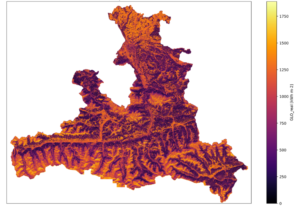
We create very-high-resolution (0.5 m) radiation data incorporating local shadowing effects (e.g. shadows cast by trees or chimneys). This is achieved by downscaling existing radiation data from the radiation model STRAHLGRID (available at a spatial resolution of 100 m and a temporal resolution of 15 min), leveraging very high resolution digital surface models derived from airborne laserscanning. The output includes global, direct and diffuse radiation components.
Background
Accurate information about solar radiation is an important basis for spatial and energy planning, particularly for assessing photovoltaic potential.
GeoSphere Austria currently provides solar potential data at a spatial resolution of 100 m and a temporal resolution of 15 minutes on an operational basis. These data are computed with the aid of the radiation model STRAHLGRID (Olefs and Schöner, 2012), which is used to calculate the ground-level shortwave radiation components (direct and diffuse radiation) on horizontal, real and arbitrarily inclined surfaces in the spectral range 0.3-3 μm as well as their component sum, the global radiation. The model incorporates effects of opacity due to water vapor and aerosols, cloud cover, horizon shading, and terrain and multiple reflections.
The cloudiness parameterization was derived from a calibration of satellite cloudiness data with ground-level measured radiation values (separately for diffuse and direct radiation). General topographic effects are included by using an adapted high-quality digital elevation model. Adapted meteorological input data (integral water vapor content, air pressure, cloud cover) from the analysis and nowcasting system INCA (Haiden et al., 2011), also operated at GeoSphere Austria, are used to model atmospheric effects. Aerosol opacity stems from GeoSphere Austria’s operational chemical forecasting system, WRF-Chem. Ground albedo (estimated from Corine land use data modified with snow cover data from MODIS) and atmospheric albedo (estimated on a grid-point basis using INCA cloud cover and WRF-Chem aerosol transmission for clear-sky albedo) are incorporated into terrain and multiple reflections.
The output of STRAHLGRID is made publicly available through the Austrian Photovoltaic Information System (APOLIS) data set, which is available on GeoSphere Austria’s data hub https://data.hub.geosphere.at/ at a spatial resolution of 100 m and a temporal resolution of one day since 2006.
By integrating a very high-resolution digital surface model (VHR-DSM) into the processing chain, the effects of near shading (e.g. shadows cast by buildings and trees) on direct and diffuse radiation can also be considered. The VHR-DSM is derived from ALS (Airborne Laser Scanning) measurement campaigns. Local topographic effects are incorporated through bilinear interpolation of the 100 m data to the resolution of the VHR-DSM, considering horizon angle and sun angle computed at the ALS-DSM scale. Local shadowing effects are also included via the sky view factor (SVF), i.e. the fraction of the visible sky at each grid point, in the diffuse radiation.

Challenge
The main challenges of this endeavour are mainly related to processing and storage resources. The high spatial (0.5 m) and temporal (1h) resolution, combined with the requirement to process extensive areas (computations are done for whole federal states of Austria) require large amounts of storage capacity for the final results, let alone for interim products. Management of compute resources (balancing CPUs and RAM), efficient I/O and efficient design of workflows is of paramount importance. Data compression levels need to be balanced between read/write speed and size on disk. The implementation is mainly written in Python and relies heavily on the Scientific Python Ecosystem and packages for handling geospatial data, as well as GRASS GIS for horizon angle computation and pysolar for determining the solar position.
Support from C-SCALE
GeoSphere Austria joined C-SCALE towards the end of the implementation phase. C-SCALE provided additional compute and storage resources after the computation for the federal state of Salzburg, Austria. A roll-out for additional federal states of Austria is currently under development.
C-SCALE services used
GeoSphere Austria is now using the following C-SCALE services:
- FedEarthData, for computing and storage resources
Testimony by a researcher at GeoSphere Austria
“We needed a processing platform for geospatial data, with high demands to I/O, dynamic management of compute resources (balancing CPUs and RAM) and large amounts of storage. C-SCALE provided the compute resources we needed.”

More information and relevant publications
Göbel, M., Schlögl, M., Lehner, S., Krautgasser, F. & Olefs, M. (2022): Development of a very high resolution solar radiation cadaster for estimating solar energy potential across the entire federal state of Salzburg, Austria. EMS Annual Meeting Abstracts (19), EMS2022-396.
Sorry, the comment form is closed at this time.